The Evington Scheme
Safer Streets Healthier Neighbourhoods (SSHN) is a Leicester project designed to discourage people using local residential streets as shortcuts, reduce speeding and minimise congestion. Traffic levels within your neighbourhood have increased in recent years. Leicester City Council worked with the Department for Transport to reduce these issues and discourage the rat running and high traffic levels by creating cul-de-sac and introducing one-way streets.
The one-way system and road closures were all introduced on an experimental basis, in order to give the most accurate understanding of whether the project was working before any money was spent on a permanent solution. The Safer Streets Healthier Neighbourhood trial has now been in place for over six months, and we have been able to collect useful data alongside public feedback.
The traffic counts that were carried out between September and November 2022 in West Evington – and May and October in East Evington – showed that overall traffic volumes had reduced through the area, including on roads without specific interventions, compared to the traffic counts taken between May and Oct in 2019. There were additionally signs of localised reductions in average vehicle speeds.
The measures were designed to discourage short car journeys, which in turn makes it easier, and safer, to move around the area on foot or by bicycle. Whilst the scheme did achieve in reducing traffic, we did not identify an increase in walking or cycling levels when compared to 2019.
1268 households were invited to complete a public opinion survey between the end of November 2022 and the end of February 2023. 267 people responded, and of those, 70% thought the scheme had a negative impact on the local area. The majority thought that driving in general had increased and that there had been no change in the levels of walking or cycling in the area. 139 people were concerned about care workers being able to access their homes and 137 people identified problems with emergency vehicles accessing their homes.
59% said that excessive traffic was still an issue in the area, though when asked what would encourage respondents to reduce car use, the majority replied with “nothing at all”.
To this end, we will be arranging for the removal of all current measures. This will happen between the 27 and 31st March. The removal of road markings and signs may take longer, but they will be masked over until such a time as they can be permanently removed.
We thank you for your patience and feedback during the experiment. We will be following up the concerns and issues raised by local residents during the trial, to see if there are opportunities to improve highway safety in the area with support from the local community.
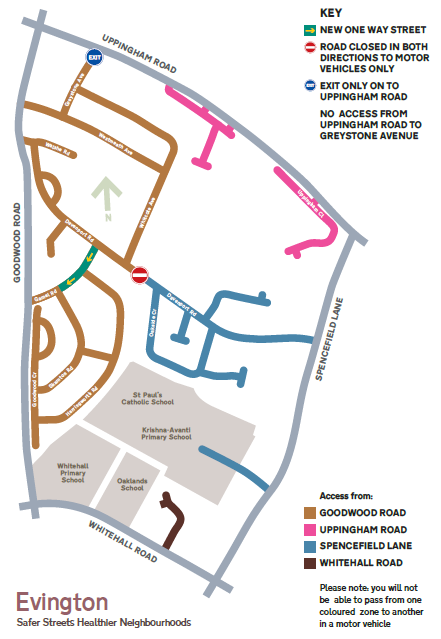
The Evington Safer Streets Healthier Neighbourhood plan that will be/has been removed week commencing 27th March 2023
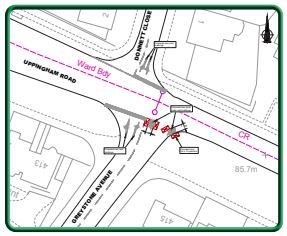
Greystone Avenue
Only the entrance from Uppingham Road into Greystone Avenue is closed to vehicles. You will still be able to exit Greystone Avenue onto Uppingham Road. Feedback from local people will be sought via a survey to be carried out in the Autumn.
Davenport Road
Whilst the scheme has gone in against the will of a number of people, the Council has heard the concerns and, where possible, has either amended the proposals already or will amend them. For example, once the closure has been left in place for a couple of weeks, the central blocks will be replaced by bollards that can be removed by the emergency services if required. If the closure is to be left in place for longer than a couple of months, the concrete blocks will be replaced with something more attractive, and the detail of what they will look like will be discussed at the residents group meetings which will commence shortly.
The Sat Nav companies have been informed. Therefore, journeys made by delivery companies and emergency services will be re-routed.
The closures are in place experimentally and if you have any objections about the Experimental Order (Parking and Moving restrictions) being made permanent these should be received in writing referencing (Evington SSHN-2979-P&M) preferably by email: SaferHealthierStreets@leicester.gov.uk by 24 February 2023. In addition, a survey will be sent to local people, once the scheme has bedded in. The survey will give you the opportunity to tell us the difference all the closures have had made to living and travelling within your neighbourhood.
We ask that you give the closures a chance and get in touch with us via the survey to let us know both the positive and negative impacts of the trial.
Newhaven Road
The exact location and size of the closure is still being trialled. A survey will be sent to local people, once the scheme has bedded in. The survey will give you the opportunity to tell us the difference all the closures have had made to living and travelling within your neighbourhood.
Mickleton Road
Mickleton Avenue closure is being removed from the scheme. However, to reduce parking on the grass verges on Whitehall Road, low wooden fences will be installed.
Gamel Road
The one-way on Gamel Road is from Davenport Road to Skampton Road. Issues around parent parking on Harringworth Road will be managed by asking parents to park in the car park of Leicester General Hospital – a 5-minute walk from the school. A survey will be sent to local people, once the scheme has bedded in. The survey will give you the opportunity to tell us the difference all the closures have had made to living and travelling within your neighbourhood.
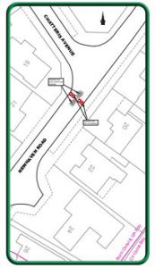
Downing Drive and Chatteris Avenue
In response to concerns about parking on the grass verges in the area, low wooden fences will be installed on some sections of Downing Drive and Chatteris Avenue.
The extent of the amended proposal can be seen on the plan over the page. Further details with timescales for the start of the experiment, will be sent out in April/May 2022.
If you have any queries, please email saferhealthierstreets@leicester.gov.uk